SFC news published since 2018. See SFC archived content for earlier news articles.
The project is supported by £51K from the University of Glasgow GCRF Small Grants Fund which enabled the project team to undertake detailed field work and run focus groups to discuss how community and individual behaviour with respect to landmine risk can be improved in Myanmar.


Detection and removal of landmines is a serious global problem with complex political, economic, environmental and humanitarian dimensions.
Landmines and explosive remnants of war (ERW) have a negative effect on physical security, economic productivity, child health and educational attainment, food security, and agriculture. The wider long-term effects of landmines are a social and economic burden to victims, their families and the wider communities.
Myanmar is widely perceived as one of the most mine-affected countries in the world. The Landmine and Cluster Munition Monitor report annual casualties of between 150 and 200, though the actual total number is expected to be much higher due to the absence of any official reporting mechanisms. Most casualties are adult males; however, it is believed that the number of women and children casualties will increase since mobility restrictions have been reduced since 2011.
Our work has led an interdisciplinary approach to improve understanding of the extent of landmine contaminated areas in Myanmar, understanding the barriers which prevent vulnerable populations from adopting safe behaviour in these areas, and exploring the role that maps have in influencing these behaviours.
The research team worked in collaboration with the HALO Trust, a charity dedicated to clearing landmines and the dangerous debris of war, to design the research project and looked at the effectiveness of HALO MRE (Mine Risk Education) evaluation forms, identifying missed opportunities for data capture and potential mismatches between how investigators and members of the public understand the questions.
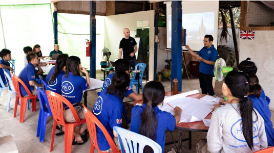
The project, supported by £51K from the University of Glasgow GCRF Small Grants Fund, enabled the project team to undertake detailed field work and run focus groups to discuss how to improve community and individual behaviour in landmine contaminated areas. A workshop was delivered to 26 HALO staff in Kayin and Northern Shan state to introduce new technologies which can improve their skills and abilities and in time, lead to improvements in HALO`s monitoring and evaluation programme, an integral part of their operations.
The project has led to two Masters students at the School of Geographical & Earth Sciences undertaking their dissertation projects with the HALO Trust on developing remote sensing-based approaches to identifying explosive remnants of war threats and the impacts such as displacement and resettlements in Cambodia and Afghanistan. These projects have developed semi-automated approaches that the HALO Trust can use operationally to assess the impact of their mine-clearance activities, by quantifying land use change and the growth of a population in a specific area over time. An agreement between the University and the HALO Trust has been signed, ensuring a long-term collaboration between the two organisations. This significant development highlights the commitment and trust between the two organisations to collaborate further, sharing sensitive information and data.
This project has formed a new network of interdisciplinary collaborators across the University, Scotland and Myanmar, promoting interactions between specialists in cartography, social sciences, and environmental remote sensing.
The outcomes of these interactions will be used to further strengthen capacity through enhanced knowledge creation and new data collection approaches that will ultimately benefit some of the world`s most vulnerable communities in war-torn countries.

